 InTouch is a management system comprised of 20* agencies throughout the state funded by DHS to serve as a link between DHS funded prevention programs, state government, to research community, and local communities.
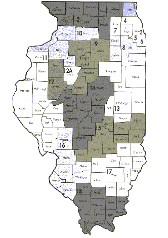
The state is divided into 19* InTouch regions, called Prevention Service Areas (PSAs). The City of Chicago is divided into five areas in conjunction with police department districts and the Chicago Together Center for Substance use disorder grant. The 19 PSAs were modeled after the Illinois State Board of Education’s (ISBE) regions allowing for ease in information sharing and analysis between DHS and ISBE.
Each community-based provider is affiliated with an InTouch office in its PSA.
*Note: PSAs are numbered 1 through 18. PSA #12 is separated into two areas 12 and 12A. This accounts for the 19 areas mentioned above. In addition Prevention First serves as the InTouch office for the City of Chicago making the number of agencies in the InTouch System a total of twenty agencies.
Communities Severed:
Alsip
Bedford Park
Blue Island
Burbank
Burnham
Bridgeview
Calumet City
Chicago Heights
Chicago Ridge
Country Club Hills
Crestwood
Crete
Dixmoor
East Hazel Crest
Evergreen Park
Flossmoor
Ford Heights
Frankfort
Glenwood
Harvey
Hazel Crest
Hickory Hills
Hometown
Justice
Lansing
Lemont
Lynwood
Markham
Matteson
Marionette
Midlothian
Oak Forest
Oak Lawn
Olympia Fields
Orland Park
Palos Heights
Palos Hills
Palos Park
Park Forest
Phoenix
Posen
Richton Park
Riverdale
Robbins
Sauk Village
South Chicago Heights
South Holland
Steger
Thornton
Tinley
University Park
West Haven
Worth